


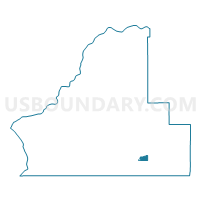
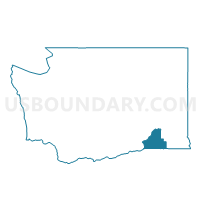
Yellowhawk Voting District, Walla Walla County, Washington
About
Outline

Summary
| Unique Area Identifier | 689947 |
| Name | Yellowhawk Voting District |
| County | Walla Walla County |
| State | Washington |
| Area (square miles) | 2.32 |
| Land Area (square miles) | 2.26 |
| Water Area (square miles) | 0.06 |
| % of Land Area | 97.24 |
| % of Water Area | 2.76 |
| Latitude of the Internal Point | 46.06896930 |
| Longtitude of the Internal Point | -118.25915460 |
Maps

Graphs
Select a template below for downloading or customizing gragh for Yellowhawk Voting District, Walla Walla County, Washington


Neighbors
Neighoring Voting District (by Name) Neighboring Voting District on the Map
- Alderbrook Voting District, Walla Walla County, WA
- Baker Voting District, Walla Walla County, WA
- Berney Voting District, Walla Walla County, WA
- Mill Creek Voting District, Walla Walla County, WA
- Pleasant Voting District, Walla Walla County, WA
- Spruce Voting District, Walla Walla County, WA
- Tausick Voting District, Walla Walla County, WA
Top 10 Neighboring County Subdivision (by Population) Neighboring County Subdivision on the Map
Top 10 Neighboring Place (by Population) Neighboring Place on the Map
Top 10 Neighboring Unified School District (by Population) Neighboring Unified School District on the Map
Top 10 Neighboring State Legislative District Lower Chamber (by Population) Neighboring State Legislative District Lower Chamber on the Map
Top 10 Neighboring State Legislative District Upper Chamber (by Population) Neighboring State Legislative District Upper Chamber on the Map
Top 10 Neighboring 111th Congressional District (by Population) Neighboring 111th Congressional District on the Map
Top 10 Neighboring Census Tract (by Population) Neighboring Census Tract on the Map
- Census Tract 9209, Walla Walla County, WA (8,508)
- Census Tract 9208.01, Walla Walla County, WA (4,915)
- Census Tract 9202, Walla Walla County, WA (3,861)